For 50 years Israel has had no clear borders. No borders means no accountability. No borders means people without rights.
Where do we draw the line?
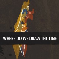
If you tried to draw the borders of the State of Israel, what would your drawing look like?
The fact is that since June 1967 it has become increasingly difficult to draw Israel’s borders; the policy in the occupied territories is one giant web of contradiction and concealment. The politicians declare that “Ariel is Israel,” but a military commander controls the area in which the settlement of Ariel is located in. The bumper-stickers announced, “The fate of Netzarim is the fate of Tel Aviv.” Yet Netzarim, a settlement in the Gaza Stip, was evacuated, while Israeli control of Gaza has not ceased. We are told that “Yesha [Judea and Samaria] is Here,”
But most of the people who live “there” are not citizens “here.” And anyone driving through the streets of “United Jerusalem” knows all too well whether they are in the West or the East of Jerusalem.
Look at the picture we drew. Does it seem logical? The ongoing blurring of the lines – here/there, ours/yours, occupation/annexation, incursion/withdrawal – has led to systematic violations of the rights of the Palestinians for fifty years. How much more suffering will be inflicted until we realize that a state without borders create a people without rights?


